We escaped the Texas heat for a long July 4th weekend by heading to the mountains of Colorado. We flew into Denver on Thursday evening, and we made the 2-hour drive west to Leadville on Friday morning. After these two carnivores mistakenly found ourselves at a plant-based restaurant for lunch, we set off for our first hike in the Mount Massive Wilderness. Thankful for the rental car upgrade to a Jeep once we hit a bumpy gravel road for 3.5 miles, we arrived at the Native Lake trailhead just as the afternoon mountain showers began. But, by the time that we geared up in our hiking boots and rain gear, the rain stopped so we stripped back down before heading up the mountain.

The Native Lake trail started with a climb through a forest. We appreciated the relatively easy terrain and moderate grade, as we weren’t acclimated to such high altitude (10,780-ft. at the trailhead with a peak elevation of 11,860-ft.). We were surprised to find brief sections of the trail still covered with snow.


We emerged from the forest after a couple of miles of climbing to a plateau with views of the mountains all around us and Leadville far below to the east. After reaching the high point of our hike, it was time to descend toward Native Lake. We agreed that the hike itself was much better than the actual destination once we arrived to the small lake.


To our surprise, we only encountered one other couple along the way, and we didn’t come across any wildlife whatsoever. After we retraced our steps back to the trailhead, it was time to head to our ultimate destination for the weekend…Buena Vista. We arrived in BV about an hour later, and we were thankful that we had pizza waiting for us to pick up once we got there (pro tip: Get the Zeppoles, Italian donut holes, for dessert).
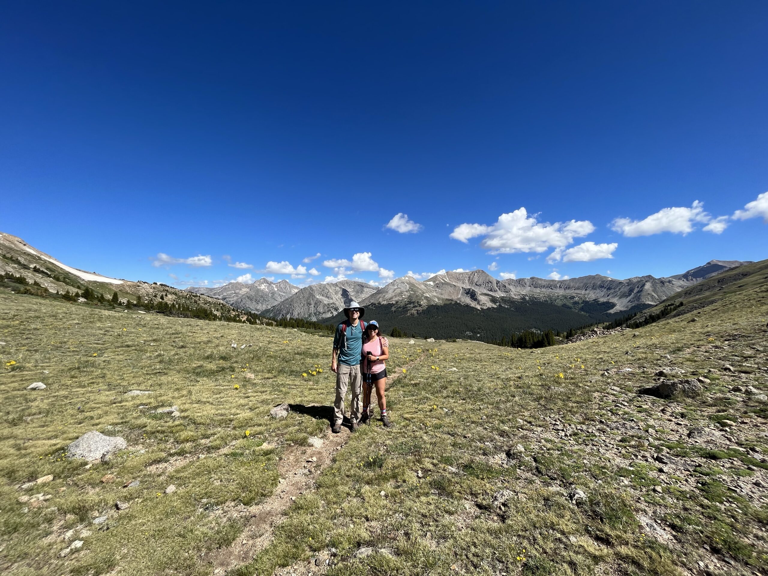
Saturday called for an early start in order to ensure that we finished our hike before the rain showers hit the mountains in the afternoon. We arrived at the Denny Creek trailhead around 7:30am, and we got one of the last (illegal) parking spots. Again, to our surprise, we had the trail to Browns Pass and beyond to the North Cottonwood Creek Divide virtually to ourselves. So, clearly most folks had arrived early and opted for the trail to summit Mount Yale instead. We had no interest or need to bag a 14’er on this trip, and we were very pleased with our trail choice for the day (although, it was definitely steeper and rockier than yesterday’s hike). This is definitely a trail to do with clear, sunny skies so that you can fully appreciate the mountain views.


Once we emerged over the top of the saddle at Browns Pass, we were rewarded with spectacular views of the surrounding mountains. We continued onward and upward to the North Cottonwood Creek Divide, and we were pleased to see all of the wildflowers in bloom (this section reminded us of the popular Highline Trail at Glacier National Park). Once we reached the divide, it was time to soak in more of the views and refuel for our descent.


We timed our hike perfectly, as we had light sprinkles of rain for the last 30-45 minutes. The goal of this trip was to get time on our feet for our upcoming trek around Mont Blanc next month. With 7.8 miles yesterday and 10.2 miles today (and, plenty of elevation gain), we felt pretty good about what we were able to accomplish, especially at this altitude. After recovering for a few hours in the afternoon, Kurt wanted a beer so we headed to Eddyline Brewery for dinner.
With the hiking portion of the trip completed, it was time to get reacquainted with thrilling rapids on our whitewater rafting trip on Sunday. The reason that we opted for a trip to Buena Vista was that it provided the opportunity to combine both hiking and whitewater rafting, which is exactly what we’ll be doing when we raft the Zambezi River in Africa after hiking Mont Blanc in Europe next month! This was our first time back in a raft since our trip to Futaleufu in Chile last December. With only one other group of three guys joining us on this trip, it was clear that most people weren’t up for the more adventurous Class IV-V rapids of Pine Creek and The Numbers on the Arkansas River. But, I couldn’t wait!! We started with a warm-up section of Class III-IV rapids from Granite then got out of the raft to scout the Class V section of Pine Creek. I’m not sure whether I liked knowing what was coming or not! But, our guide was very experienced and safely got us through that section, which is the the steepest section of the Arkansas River (dropping about 100 feet over a half mile).
Then, it was onto The Numbers, a series of seven rapids designated by numerals.


We definitely worked up an appetite after all of that paddling (which wore us out more too because we were at 8k feet). So, we enjoyed the chicken fajitas that were waiting for us once we arrived at the takeout spot at Riverside campground.
Kurt opted to go shake-out his legs with a run around town later that afternoon. BV is such a small town with few restaurants (that fill up quickly, especially during such a busy weekend), so we ordered take-out from Crave for dinner (pro tip: The pizza was even better than Elkhorn, although smaller).
Monday morning was my turn to feel what it’s like to run at 8,000 feet, as we did a fun run at the town’s holiday 5k event. The course started and finished on East Main Street, where people lined up for the parade that immediately followed the race. The middle section of the run was on the narrow dirt trail by the river. Given the altitude and all of the activities in the preceding days, there was no “racing” for either of us (although, Kurt still managed to finish in the top 20). But, it was a fun way to kick off the 4th of July with the locals!


We wrapped up our trip with a drive up to Cottonwood Pass (12,126 feet). We had hiked up to 12,550-ft. at North Cottonwood Creek Divide on Saturday, so I was happy to trade my hiking boots for the car this time!


